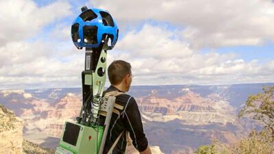
If you’ve ever wanted to hike the Grand Canyon but are too lazy to leave your house, then you are in luck! In a project called Google Grand Canyon, the Google Maps team mounted their Google Street View camera rig to backpacks and sent a team to map several Grand Canyon hiking trails. The end result is the ability to virtually hike the Grand Canyon using Google Street View.
Google’s Quest To Map Everything From The Moon To The Grand Canyon
Since February 2005, Google has been very aggressive in its quest to map the Earth and beyond with projects like Google Sky, Google Moon, and Google Mars. But the Google Grand Canyon project might be their most ambitious off-road quest on Earth. Google Grand Canyon includes Google Street View images that cover more than 75 miles of trails and surrounding roads. You can read more about the Google Grand Canyon project here.
Skelton Point On The South Kaibob Trail
Trail Of Time
Google Grand Canyon Highlights
The Grand Canyon has so many beautiful and scenic points. Here are just some of the things that you can see and explore using Google Grand Canyon beyond what we’ve highlighted in this article.
- Take a virtual hike down the exposed paths of the Grand Canyon
- Hike down the famous Bright Angel Trail
- Gaze out at the mighty Colorado River
- Visit the Grand Canyon’s neighbor, the Meteor Crater
More Fun With Google Maps & Google Street View
If all of this virtual national monument exploration wears you down, then you can always come back to reality by ogling some of the naked people that Google’s cameras have captured over the years.

Frank Wilson is a retired teacher with over 30 years of combined experience in the education, small business technology, and real estate business. He now blogs as a hobby and spends most days tinkering with old computers. Wilson is passionate about tech, enjoys fishing, and loves drinking beer.


 How To Use Your iPad Mini As A Phone – Tutorial
Leave a Reply
You must be logged in to post a comment.